Directions to Red Rock Ranch
Coming from the Denver International Airport
Exit the Airport (Pena Blvd). Take the toll-road C470 south. (About 2-3 miles from Airport) You’ll go through several toll stations ($1.75 each) until you come to I-25. Take I-25 south, through Colorado Springs. After going past downtown (on your left), you’ll proceed for several miles. Take the Circle Drive exit. At the bottom of the off ramp, go right. You are now on Lake Street (Circle drive is left). Head towards the mountains (West) a few miles until you come to Hwy 115. Make a left (south) onto Hwy 115 (after you’ve gone under the overpass). Now follow >>> directions below.
Coming from the Denver area
Take I-25 south, through Colorado Springs. After going past downtown (on your left), you’ll proceed for several miles. Take the Circle Drive exit. At the bottom of the off ramp, go right. You are now on Lake Street (Circle drive is left). Head towards the mountains (West) a few miles until you come to Hwy 115. Make a left (south) onto Hwy 115 (after you’ve gone under the overpass).
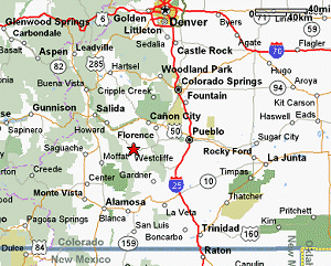
>>> Proceed south on Hwy. 115 (Note: A couple of miles down at Academy exit is a large Safeway shopping center. Great stop for groceries.) continue about 30 miles on Hwy. 115 until you reach Penrose. Stay on Hwy 115 straight through Penrose and over Hwy 50. Florence is about 6 more miles. In Florence proceed to the first traffic light (Carl’s Jr. is on your left). Turn left here onto Highway 67 and proceed for about 10 miles. This will dead-end at the small town of Wetmore. You can either go right or left onto Highway 96. Turn right on Hwy 96 (west into the mountains) and proceed about 20 miles to mile marker #6.
*** Slow down when you reach mile marker #7, as the turn you will make at mile marker #6 is quite sharp and can be dangerous if you are going too fast. At mile marker #6 turn right onto County Road 260
+++ Go exactly a half mile to the mailbox marked 525 – you will see iron gates flanked by large lodge poles, enter the driveway here and proceed about a mile to the next set of iron gates near the houses. The gate code will be posted on the gate entry pad. Press firmly and slowly on the keypad. Come in and park in the gravel driveway.
Coming from Colorado Springs Airport
Exit the airport. This puts you straight onto Drennan Road. Stay on Drennon Road through several stoplights until you reach Academy Blvd. Turn left (south) on Academy. After a few miles you’ll pass under Interstate 25. Keep going west toward the mountains for another 3-4 miles until you see the Safeway shopping center up on your right. Before the shopping center, make a left onto Hwy 115. Follow directions after >>> under “Coming from the Denver Area” above.
From Pueblo
From I- 25 exit 6th street and follow signs for Colorado Hwy 96. (You’ll go west to Santa Fe and turn left (south), proceed two blocks to 4th street and turn right (west).) Stay on Hwy 96 (it has many names as you proceed through Pueblo but you want to stay on this road – it is Hwy 96). You’ll leave the Pueblo area on Hwy 96. You’ll pass Pueblo reservoir, and continue heading west towards the mountains. Take Hwy 96 about 50 miles to mile marker #6, and follow directions after *** under “Coming from the Denver Area” above.
From Western Colorado
Find your most convenient route to the town of Salida. Follow Highway 50 east along the Arkansas River about 24 miles to the town of Cotopaxi. In Cotopaxi there is only one right you can take that is such a backroad it has no number, but it will indicate that it is a route to Highway 69 and Westcliffe. Follow that road about 8 miles to Highway 69 and turn right (south). In the town of Westcliffe turn left (east) on Highway 96. Follow Hwy 96 several miles and slow down as you approach mile marker 6 and make a left turn onto County Road 260 and follow directions after +++ under “Coming from the Denver Area” above.
Coming up the Valley on Hwy 69 (From Walsenburg, Gardner or Pass Creek)
When you come into the town of Westcliffe, make a right onto Hwy 96 (Antler Liquor is on your left…you make a right). Go approximately 6 miles to mile marker #6. Make a left onto County Road 260. Go exactly 1/2 mile. The driveway is to your left and is flanked by lodge pole fencing, timbers and an iron gate. The mailbox has the numbers 525. The driveway is approximately 1 mile long so you won’t see the houses. You will come to a gate with key pad entry. The code will be posted on the gate entry system.